


Add Your Business
Green Eco Software Categories
Green Eco Software Companies
The Australian Spatial Data Directory (ASDD) is a national initiative supported by all governments under the auspices of ANZLIC - the Spatial Information Council....
MOREWallingford Software develops world-leading water management software for water supply and distribution, wastewater and stormwater, river and coastal systems and...
MOREWallingford Software develops leading water resource management software for the worldwide water industry. Recognised for its technical superiority and unrivalled...
MOREAt Ozeco design we work with clients to achieve sustainable and energy efficient residential housing design. We do what we can to design sustainable housing within...
MOREColourful WaterWise Gardening Software Version 6.0.Latest Version Now Available!The Gardening Software and Plant Database for Colourful Xeriscape, WaterWise, and...
MOREEquilibrium OMG brings together expertise and experience across environmental knowledge, corporate, technical, government and communications to offer practical...
MOREeBMS provides a large range flexible web based, workflow enabled environmental business management systems. Our business management software assists with...
MOREGreen Eco Software Companies
Touch Down Technologies

Touchdown Technologies designs, manufactures, and...
Australian Spatial Data Directory
The Australian Spatial Data Directory (ASDD) is a national initiative supported by all governments under the auspices of ANZLIC - the Spatial Information Council....
Wallingford Software
Wallingford Software develops world-leading water management software for water supply and distribution, wastewater and stormwater, river and coastal systems and...
OzECO
Passion Computing provides a range of website design, domain name and hosting services that enable you to do business effectively on the internet. From affordable...
Wallingfordsoftware.com
Wallingford Software develops leading water resource management software for the worldwide water industry. Recognised for its technical superiority and unrivalled...
Ozeco Design
At Ozeco design we work with clients to achieve sustainable and energy efficient residential housing design. We do what we can to design sustainable housing within...
Green Eco Software Products
Updated Lower Hunter Central Coast Regional Environmental Management Strategy Vegetation Mapping (2002): Arcview GIS and C-plan software were used to identify the...
MORE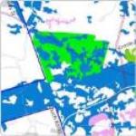
Gis Projects
Updated Lower Hunter Central Coast Regional Environmental Management Strategy Vegetation Mapping (2002): Arcview GIS and C-plan software were used to identify the...
Green Eco Software Categories
Go Net Zero today
Carbon-Zero Me more
Copyright © Greenfinder 2024
Copyright © Greenfinder 2024