


Add Your Business
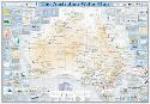
The Australian Water Map
The Australian Water Map is reserve for those people who are conscious in water-related issues that are specialized and want to help prepare solutions for key water trends, statistics and noteworthy events, and also students who want to get acknowledged about the major concerns that are facing Australia's water source management and utilization.
Following are the features of spatial component of The Australian Water Map: -
a) Salinity
b) Black spots
c) Water Users
d) Water History
e) Altered Rivers
f) Ramsar Wetlands
g) Coastal Pollution
h) Permanent Rivers
i) Permanent Lakes
j) Ephemeral Lakes
k) Wild River Basins
l) Water Phenomena
m) Threatened Species
n) Introduced Species
o) Aquatic Biodiversity
p) Great Artesian Basin
q) Extreme Water Events
r) Major River Diversions
s) Major Irrigation Districts
t) Polluted Rivers and Lakes
u) Major Water Achievements
v) Major Hydroelectric Power Sites
w) Coastal Treatment Discharge Points
x) Water Recycling and Treatment Initiatives
y) Drainage Divisions: - Inward & Coastal Draining